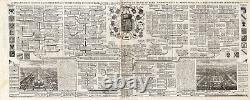
Large Antique Print-GENEALOGY-ROYAL-BRUNSWICK-LUNEBOURG-HANOVER-Chatelain-1732


Original Antique Maps and Prints. Description: This original old antique print / plate originates from the fifth volume of:'Atlas Historique...
, Published by Zacharie Chatelain, Amsterdam, 1732. The atlas was published in seven volumes between 1705 and 1720, with a second edition appearing in 1732. The maps were accompanied by information pertaining to cosmography, geography, history, chronology, genealogy, topography, heraldry, and costumes of the world. The maps in the Atlas Historique were mainly based on those of the French cartographer, Guillaume De L'Isle, but were presented by the Chatelains in an encyclopaedic form. We do not know the exact edition of this map.Subject: Very large original antique print, titled'Carte Genealogique de la Famille Royale de Brunswick - Lunebourg - Hanover & les Differentes Branches Qu'elle a Formees avec les Armes Roiales & Electorales de cette Famille'. It shows: the genealogy of the Brunswick-Luneburg-Hanover Royal family, including two engravings of their palaces and gardens. Condition: Very good, given age. Assembled from 2 plates glued together as issued.
Irregular paper edges with small tears. Size (in cm): The overall size is ca.
111.5 x 44.5 cm. The image size is ca.
105 x 42.5 cm. Size (in inch): The overall size is ca.43.9 x 17.5 inch. 41.3 x 16.7 inch. Medium: Original Etching/engraving on a verge type handlaid paper. Location: B8-04 SKU: TPC 40381.1 Section: CHATELAIN-1732. ThePrintsCollector - LaurentiusOldMasterPrints Frans Laurentius Margo van Latum-van Dongen, Frank van Latum Located in Zeeland (Noord-Brabant) - The Netherlands.
GO TO OUR STORE and explore our huge collection of fine antique maps and prints.

