
1840 Large Antique Map WESTERN COAST OF AFRICA Isles de Loss Sherboro Island
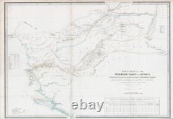

1840 Large Antique Map WESTERN COAST OF AFRICA Isles de Loss Sherboro Island. 1840 MAP OF PART OF THE WESTERN COAST OF AFRICA EXTENDING FROM THE ISLES DE LOSS TO SHERBORO ISLAND Particularly exhibiting the discoveries lately made to the N. Of Sierra Leone by Surgeon O'Beirne and Major Laing.
Overall size approx 66.5cm x 96.5cm. Rare separately issued map of a part of West Africa, showing Sierra Leone and the Southwestern Part of Guinea, published in London by James Wyld. Wyld's map presents one of the most detailed treatments of the country of Sierra Leon to appear on a printed map in the 19th Century.
The map shows in fine detail, the rivers, towns, and roads in the region. Of note, the map shows the routes of the explorations in the region by Wall & Winterbottom (1794), Surgeon O'Beirne (1821), Major Laing (1822) and Jack Le Bore (1822). ", providing an excellent annual report of British Trade with Sierra Leone, including categories defined as "Liberated Africans" and "Nova Scotians disbanded Black Soldiery &c.
PRINTS MAPS HISTORICAL DOCUMENTS POSTAL HISTORY BOOKS POSTERS STAMPS POSTCARDS EPHEMERA And anything else that is considered Antique and made of Paper. ALL OF OUR ITEMS ARE ORIGINAL ANTIQUES - NOT MODERN COPIES.