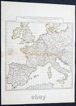
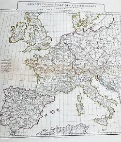
1794 Laurie & Whittle Large Antique Map Western Europe Italy, Spain, France, UK


Published 12th May 1794 by Laurie & Whittle.. Laurie and Whittle active fl. 27in x 21in (585mm x 520mm). This large original hand coloured copper plate engraved antique map of Western Europe after Jean-Baptiste Bourguinon D Anville was updated and published by Laurie & Whittle in 1794 - dated - for their Elephant Folio General Atlas. Paper thickness and quality: - Heavy and stable Paper color : - off white Age of map color: - Original Colors used: - Yellow, Green, pink General color appearance: - Authentic Paper size: - 27in x 21in (585mm x 520mm) Plate size: - 20 1/2in x 19 1/2in (510mm x 480mm) Margins: - Min 1/2in (12mm). Margins: - None Plate area: - Restoration alond left side of centerfold with slight loss Verso: - Repair as noted, light soiling. Laurie was apprenticed to Robert Sayer in 1770 and was freed of his tenure 1777. He was a skilled artist, who exhibited at the Society of Artists from 1770, winning a silver palette for a drawing in 1770, and he was also an accomplished engraver of mezzotint portraits and produced views and other decorative items.
James Whittle, who was apprenticed into the Needlemakers Company, was freed from his tenure in 1792 and joined with Laurie to complete the takeover of the Sayer business, in the same year. The foundation of their business was the existing Sayer stock of printing plates, both for single maps, atlases and also decorative prints. They continued to add new material and to freshen up the atlases, as well as separately-published maps on topical issues, notably events during the Napoleonic Wars. His son Richard Holmes Laurie replaced him in the partnership and, eventually, took over the firm after Whittles death in 1818. Under the influence of Richard Laurie, the partnership became noted as chart-makers and publishers.
After Lauries death the publishing house and its printing stock came under control of Alexander George Findlay, who had long been associated with Laurie and Whittle. Since, Laurie and Whittle has passed through numerous permeations, with part of the firm still extant as an English publisher of maritime or nautical charts, Imray, Laurie, Norie and Wilson Ltd.
The firm remains the oldest surviving chart publisher in Europe. Please note all items auctioned are genuine, we do not sell reproductions. A Certificate of Authenticity (COA) can be issued on request. What is an Antique Map. The word Antique in the traditional sense refers to an item that is more than a hundred years old. The majority of antique maps for sale today come from books or atlases and have survived due to the protection offered by the hardback covers. The first thing to determine when staring a collection or purchasing an item, is what is important to you.Most collectors prefer to build their collections around a theme. You may decide to collect maps from one region or country, charting its development through time.
Similarly you could collect maps of one particular period in time, by type i. Sea or celestial charts or by cartographer.
The collector might also want to consider the theme of cartographical misconceptions such as California as an island or Australia as Terra Australis or the Great Southern Land. The subject is so wide that any would-be-collector has almost endless possibilities to find his own little niche within the field, and thereby build a rewarding collection. Starting a collection & pricing. Pricing is based on a number of different factors, the most important of which is regional.
In any series of maps the most valuable are usually the World Map and the America/North America. The World because it is usually the most decorative and America because it has the strongest regional market. Other factors that come into play re: price is rarity, age, size, historical importance, decorative value (colour) and overall condition and quality of paper it is printed on. As specialised dealers, we frequently work with first time map buyers who are just starting their collection. Classical Images was founded 1998 and has built an excellent reputation for supplying high quality original antiquarian maps, historical atlases, antique books and prints. We carry an extensive inventory of antiquarian collectibles from the 15th to 19th century. Our collection typically includes rare books and decorative antique maps and prints by renowned cartographers, authors and engravers.Specific items not listed may be sourced on request. Classical Images adheres to the Codes of Ethics outlined by the Antiquarian Booksellers Association of America (ABAA). We are a primarily an online based enterprise, however our inventory may be viewed by appointment.
Attention Sellers - Get Templates Image Hosting, Scheduling at Auctiva. This item is in the category "Antiques\Maps, Atlases & Globes\Europe Maps". The seller is "searching01" and is located in this country: AU. This item can be shipped worldwide.

